
The Most Reliable GPS Tracker Devices For Hiking in 2022
I am one of the most directional people I know. You can take me somewhere, full of twists and turns, with lots of paths and ways that look like one another, and chances are I can get us back out.
And… I’ve still gotten lost a handful of times out in the wilderness. It’s very easy to do and it can come to be before you know it.
Different lighting at certain times of the day can cast shadows and create a whole different scene than what you saw coming in, and that’s just one factor.
That’s why it’s important to “leave a trail of breadcrumbs”, so to speak. Those of us with a passion for outdoor adventure want to immerse ourselves in nature as deeply as we can and we sometimes make mistakes. Sometimes we get lost.
Fortunately these days we have means to be found when we get lost. We have a means to track our steps, reach out for help, and get information quite literally anywhere in the world that has contact with a satellite.
I am talking of course about the Global Positioning System (GPS).
We have GPS tracking technology on our list today that can allow us to go to the most remote corners of the world, where there are no services, whatsoever, and get LOST for just under 3 years, and then still have the ability to turn to our little device and find our way back home. We can even send out an S.O.S over a global system and get found and rescued!
Using the worldwide coverage of the Iridium satellite network is how this is possible. So much more is possible, from aviation services, to real-time tracking location whereabouts, and NOAA weather info and alerts delivered to you, even out in the TAIGA!
We have compiled extensive and detailed information, taken straight from the source for you today in hopes to leave no confusion as to how these units work and which may suit your needs and budget.
So, let’s take a look at some of The Most Reliable GPS Tracker Devices for Hiking in 2021.
Disclosure: This website uses affiliate links, meaning: at no additional cost to you, we earn a small commission if you click-through and make a purchase. As an Amazon Associate I earn from qualifying purchases. We only feature products that we believe in and use ourselves. Your support means the world to us and allows us to host this website. Thank you!
the 5 best gps tracking devices for hiking in 2022
Garmin Fenix 6 Sapphire
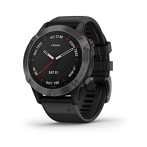
The Fenix 6 Series from Garmin is a mind-blowing, premium multi-sport GPS watch, that features mapping, music, grade-adjusted pace guidance and pulse Ox sensors.
Without the constraints of a hand-held unit, this wearable all-encompassing GPS tracker is perfect for the outdoor enthusiasts who enjoy NO limitations. In fact, just about the only thing that this watch will not do for you is actually HIKE! You still have to do that for yourself.
This is by far the best watch by Garmin and quite possibly the best watch on the planet. With incredible battery life, your exploration logistics do not have to include how much power your navigational unit has.
The Garmin Fenix 6 series has more features than you’re probably ever actually going to use, but getting to know this little machine would be wise, as you never know what the future will bring or which amazing feature may become helpful in your daily life, not just on the trail.
It’s hard to believe that one of the most amazing navigational and informational tools in the world is not only extremely comfortable, but almost unnoticeable and worn on your wrist. With the Garmin Fenix 6 series, when you reach new heights, your watch goes with you!
QUALITY BY DESIGN
The rugged yet sophisticated design features an always-on 1.3” display that’s 18% larger than previous Fenix models. It is tested to U.S. military standards for thermal, shock and water resistance.
PREMIUM MATERIALS
Fit the look to your lifestyle with your choice of stainless steel, titanium or DLC coated bezels. Each Sapphire edition adds a scratch-resistant sapphire lens and premium materials.
FEATURES:
SPORTS APP: Use preloaded activity profiles for trail running, swimming, running, biking, hiking, rowing, skiing, golfing and more.
BACKCOUNTRY SKI: Stay informed when you’re in the snow. This preloaded profile can distinguish between skiing and climbing. It automatically shows metrics specific to either ascent or descent.
ANIMATED WORKOUTS: This watch features easy-to-follow, animated cardio, strength, yoga and Pilates workouts you can view on the watch screen. Choose from preloaded animated workouts, or download more from Garmin Connect online community.
POWER MANAGER: View how various settings and sensors impact your watch’s battery life, so you can make battery-extending changes on the fly.
WRIST-BASED HEART RATE: Optical heart rate technology gauges activity intensity as well as heart rate variability to calculate your stress level. It also tracks underwater without a heart rate strap.
BODY BATTERY ENERGY MONITOR: Optimize your body’s energy reserves, using heart rate variability, stress, sleep and other data to gauge when you’re ready to be active or when you may need to rest.
HYDRATION TRACKING: Log daily fluid intake as a reminder to stay hydrated. When auto goal is enabled, you’ll even see estimated sweat loss after an activity and your goal will adjust accordingly.
PERFORMANCE METRICS: View advanced training metrics that include running dynamics, heat- and altitude-adjusted VO2 max, recovery adviser and more.
PACEPRO TECHNOLOGY: A first-of-its-kind PacePro feature helps keep you on pace with grade-adjusted guidance as you run a course.
BATTERY LIFE: Internal, rechargeable lithium battery provides up to 14 days of battery life in smartwatch mode, 10 hours in GPS mode with music and up to 48 days in battery saver mode.
CLIMBPRO FEATURE: Use ClimbPro ascent planner on downloaded courses to see real-time information on your current and upcoming climbs, including gradient, distance and elevation gain.
MULTI-GNSS SUPPORT: Access multiple global navigation satellite systems (GPS, GLONASS and Galileo) to track in more challenging environments than GPS alone.
ABC SENSORS: Navigate your next trail with ABC sensors, including an altimeter for elevation data, barometer to monitor weather and three-axis electronic compass.
PULSE OX SENSOR: For altitude acclimation or sleep monitoring, a Pulse Ox2 sensor uses light beams at your wrist to gauge how well your body is absorbing oxygen.
RESPIRATION TRACKING: See how you’re breathing throughout the day, during sleep and during breath-work and yoga activities.
EXPEDITION MODE: Trek far and wide between recharges. Expedition mode, an ultra-low-powered GPS reference, lasts for weeks.
TOPO AND SKI MAPS: Use topographical maps to navigate your adventures. View run names and difficulty ratings for 2,000 worldwide ski resorts.
ROUND-TRIP ROUTING: Enter a distance you want to travel, and get suggested routes that will bring you back to your starting point. Trendline popularity routing helps you find the best local paths.
TURN-BY-TURN NAVIGATION: Follow a route or course with help from turn-by-turn directions, which let you know ahead of time when the next turn is coming.
SMART NOTIFICATIONS: Receive emails, texts and alerts right on your watch when paired with a compatible device.
BLUETOOTH & MUSIC APPS: Store up to 2,000 songs, or access streaming apps from compatible services, including Spotify, Deezer and Amazon Music.
SAFETY AND TRACKING FEATURES: If you feel unsafe or if your watch senses that an incident occurred, assistance and incident detection features send your location to emergency contacts.
SPECS:
LENS MATERIAL: Corning Gorilla Glass DX or Sapphire Crystal
BEZEL MATERIAL: Stainless Steel, Titanium or Diamond-Like Carbon (DLC) Coated Steel
CASE MATERIAL: Fiber-Reinforced Polymer with Metal Rear Cover
QUICKFIT WATCH BAND COMPATIBLE: Included (22 mm)
STRAP MATERIAL: Silicone, Leather, Titanium or Nylon
PHYSICAL SIZE: 47 x 47 x 14.7 mm
FITS WRISTS W/ THE FOLLOWING CIRCUMFERENCES:
Silicone band: 125-208 mm
Leather band: 132-210 mm
Fabric band: 132-210 mm
Metal band: 132-215 mmCOLOR DISPLAY SIZE: 1.3” diameter
DISPLAY RESOLUTION: 260 x 260 pixels
DISPLAY TYPE: sunlight-visible, transflective memory-in-pixel (MIP)
WEIGHT: Steel: 83 g - case with silicone band (case only: 60 g)
Titanium: 72 g - case with silicone band (case only: 49 g)BATTERY LIFE: Smartwatch Up to 14 days
GPS: Up to 36 hours
GPS and Music: Up to 10 hours
Max Battery GPS Mode: 72 hours
Expedition GPS Activity: 28 days
Battery Saver Watch Mode: 48 daysWATER RATING: 10 ATM
MEMORY/HISTORY: 32 GB
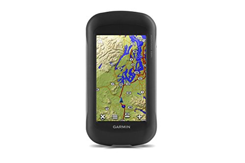
Not only does the Montana 680T share the name of one of our most beloved states here at Rugged Man, but it is also an amazing piece of technology!
The Montana 680T features a dual-orientation, 4” color touchscreen (that’s glove friendly) and comes preloaded with TOPO 100K U.S. maps and includes a 1 year BirdsEye Satellite Imagery subscription.
The 8 megapixel digital camera provides high-quality images, excellent resolution, and it automatically geotags photos with coordinates, allowing you to navigate back to your exact favorite spots in the future.
The Montana 680T also includes a 3-axis compass, barometric altimeter, and access to both GPS and GLONASS satellites for improved positioning and typically faster fixes. High-sensitivity GPS holds your position even in the deepest cover.
Another handy feature included with the Montana 680T is 250,000 preloaded geocaches from Geocaching.com. Share your waypoints, tracks, routes and geocaches wirelessly with other compatible Garmin GPS users.
Bumps, humidity and water are no match for the durable Montana 680T. With a Water-rating of IPX7, this machine is just as ready as you are to hit the trails and not look back!
FEATURES:
FIND FUN
Montana supports paperless geocaching GPX files for straight-to-device uploading of geocaches from Geocaching.com. No more manually entering coordinates and paper print outs, Montana stores and displays key information, including location, terrain, difficulty, hints and descriptions. The track manager feature helps organize and navigate through waypoints/routes/ and track logs (easily start/stop recording tracklogs).
KEEP YOUR FIX
With its high-sensitivity GPS and GLONASS reception, WAAS-enabled receiver and HotFix satellite prediction, Montana locates your position quickly and precisely and maintains it. Whether you’re in deep woods or just near tall buildings and trees, count on Montana to help you find your way when you need it most.
ENJOY THE VIEW
Montana has a vast 4-inch, sunlight-readable touchscreen display, giving you vivid colors and high-resolution images. Its easy-to-use touchscreen means you’ll spend more time enjoying the outdoors and less time searching for information.
PLAN YOUR NEXT TRIP
Our free BaseCamp software lets you view and organize maps, waypoints, routes and tracks. This free trip-planning software even allows you to create Garmin Adventures that you can share with friends, family or fellow explorers. BaseCamp displays topographic map data in 2-D or 3-D on your computer screen, including contour lines and elevation profiles.
SPECS:
PHYSICAL DIMENSIONS: 2.9" x 5.7" x 1.4"
TOUCHSCREEN DISPLAY SIZE: 2"W x 3.5"H; 4" diag
DISPLAY RESOLUTION: 272 x 480 pixels
DISPLAY TYPE: bright, transflective 65K color TFT, dual-orientation touchscreen; sunlight readable
WEIGHT: 10.2 oz with included lithium-ion battery pack; 11.7 oz (333 g) with 3 AA batteries (not included)
BATTERY: rechargeable lithium-ion (included) or 3 AA batteries (not included); NiMH or Lithium recommended
BATTERY LIFE: up to 16 hours (lithium-ion) | up to 22 hours (AA batteries)
WATER RATING: IPX7
INTERFACE: high speed mini USB and NMEA 0183 compatible
MEMORY/HISTORY: 8 GB (user space varies based on included mapping)
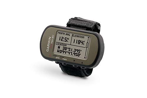
The Foretrex 401 is another amazing wrist-mounted GPS navigator perfect for outdoor activities that require the use of both hands.
Its slim and slender design make it hardly noticeable while tending to the things that are most important when you’re hiking and immersing yourself in the great outdoors.
Combining a high-sensitivity waterproof GPS receiver, electronic compass, and barometric altimeter into a lightweight device ideal for hikers, skiers, and campers, the Foretrex 401 also shares data easily. You can connect Foretrex to your computer with USB or just send data wirelessly to another device. That simple!
RETRACE YOUR STEPS
No matter where your adventure takes you, you'll never worry about getting lost with the Foretrex 401. Foretrex keeps track of your path and displays it as a dotted trail on the screen. Just turn on Foretrex's TracBack feature, and you can retrace your path back to where you started.
Keep track of your bearing and altitude with Foretrex 401's electronic compass and barometric altimeter. You can save locations in memory as waypoints, so you always can find your way back to any important place, like your campsite or vehicle. And with up to 17 hours of battery life and replaceable AAA batteries, you'll never worry about making it back.
TRACK YOUR DATA
The Foretrex 401 lets you create and store routes to all of your favorite places and provides other helpful information, including a trip computer, sunrise/sunset times and hunting and fishing information.
For even more data, connect Foretrex 401 to a wireless accessory, such as a heart rate monitor, cadence sensor, or clip it on your bike with the accessory bike mount.
To keep track of your trip, connect your Foretrex to your PC or Mac with USB to store your waypoints, routes and tracks on your computer. You also can share waypoints, routes and tracks wirelessly with another Foretrex 401.
GET CONNECTED
You've been busy exploring and now you want to store and analyze your activities. With a simple connection to your computer and the Internet, you can get a detailed analysis of your activities and send tracks to your outdoor device using Garmin Connect.
This one-stop site offers an activity table and allows you to view your activities on a map using Google Earth. Explore other routes uploaded from more than 12 million customers and share your experiences on Twitter and Facebook. Getting started is easy, so get out there, explore, and share!
FEATURES:
Includes: Wrist expansion strap, USB cable, Manuals
High Sensitivity GPS Receiver: w/ HotFix for improved performance and reception in heavy tree cover or deep canyons
Keeps track of routes, tracks and waypoints, and heart rate with add on heart rate monitor (sold separate). Uses standard AAA batteries. 2 required.
TracBack Feature: Retraces user's path on the easy-to-read LCD display
Supports dual position readout so user can view current location in multiple formats. Audible tones. Hold the compass level when navigating to ensure maximum accuracy
Hunting/Fishing Information
Trip Computer
Electronic Compass
Barometric Altimeter
Clock Features: Time/date, GPS time sync, Automatic Daylight Saving Time, Alarm Clock, Timer, Stopwatch, Sunrise/Sunset Times
Customizable Data Pages
Bread Crumb Trail: In Real Time
Elevation Profile
Barometric Trend Indicator
SPECS:
PHYSICAL DIMENSIONS: 2.9" x 1.7" x 0.9"
DISPLAY SIZE: 1.6"
DISPLAY RESOLUTION: 100 x 64 pixels
DISPLAY TYPE: black and white LCD
WEIGHT: 3.1 oz with batteries
BATTERY: 2 AAA batteries (not included)
BATTERY LIFE: Up to 17 hours in GPS mode
WATER RATING: IPX7
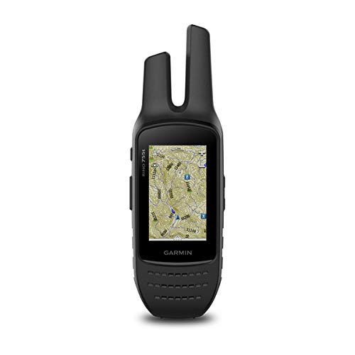
The Garmin Rino 755T is a rugged handheld 2-Way Radio, a GPS/GLONASS Navigator, a camera, and a preloaded TOPO Mapping machine that is ready to join you for the long haul!
Ready to handle just about any conditions, this waterproof beast combines map-guided trail navigation with two-way radio communication.
The Rino 755T handheld brings a whole new level of confidence to your outdoor adventures by featuring a unique position reporting capability that lets you send your exact location to other Rino users so they can see it on their map displays.
FEATURES:
COMMUNICATE BY VOICE OR TEXT
The Rino 755T features powerful 5 W GMRS two-way radio that lets you easily stay in touch with your fellow hunters, hikers or explorers in the field. You can also maintain nonverbal contact by exchanging unit-to-unit text messages with other Rino users in your area.
PINPOINT YOUR POSITION
Dual GPS and GLONASS satellite reception enables our Rino series handhelds to accurately track and maintain your position, even in heavy cover, deep canyons or remote, off-the-grid locations. Each Rino also lets you share your waypoints, tracks, routes and geocaches wirelessly with other compatible Garmin handheld devices.
A built-in barometric altimeter and 3-axis compass make it easy to get your bearings. The Rino 755T supports advanced mapping capabilities such as BirdsEye Satellite Imagery (1-year subscription included). In addition, the 755T comes with an 8-megapixel camera plus preloaded TOPO 100K mapping for an even more detailed view of the terrain.
GEO-TAG PICTURES
Rino 755T has a built-in digital camera that makes it easy to capture locations, scenic views and memories of your travels. Each photo is automatically geo-tagged with coordinates, allowing you to navigate back to that exact spot in the future.
Keep track of your photos and see their locations conveniently on a map using BaseCamp outdoor trip-planning software, which lets you view and organize maps, waypoints, routes and tracks. BaseCamp can also transfer satellite images to your device when paired with a BirdsEye Satellite Imagery subscription.
SEE YOUR SURROUNDINGS
The Rino 755T handheld comes with a worldwide shaded-relief basemap. With our wide array of detailed topographic, marine and road maps available, it’s easy to install additional mapping products.
KEEP A CLOSE EYE ON THE WEATHER
With support for Active Weather forecasts and animated radar tracking, Rino 755T gives you a vital edge in weather awareness. Get real-time conditions, forecasts and alerts (in areas with coverage) directly on your handheld display when the Rino is paired with a compatible smartphone and the Garmin Connect Mobile app.
For added situational awareness, a built-in NOAA weather radio supports Specific Area Message Encoding, which allows you to see National Weather Service warnings and watches displayed county-by-county on the map screen.
WIRELESS CONNECTIVITY FEATURES
Syncing your Rino 755T handheld with a compatible Bluetooth-enabled headset enhances your radio communications, even under adverse weather or windy conditions.
By syncing your device with a compatible smartphone, you can also receive smart notifications (calls, texts, emails and more) right on your display so you can stay focused on the trail ahead while staying connected with friends and family back home.
THINK RUGGED AND ROBUST
Durable and waterproof at a rated IXP7, the Rino 755T series is built to keep you in touch and on track, no matter what the elements throw at you. Each device features a vivid, dual-orientation, 3” color touchscreen that’s glove-friendly and easy to read, even in bright sunlight. And a dual battery system lets you use the included rechargeable lithium-ion power pack or AA battery pack (sold separately).
TURN YOUR COMPUTER INTO A BASE STATION
Garmin BaseStation lets you turn your laptop (BaseCamp software required) into a field command center for tracking multiple Rino units. View real-time GPS information on the larger display of your computer while Rino serves as a router/antenna. And because it’s Garmin GPS-based, you're in control of more effective search and rescue operations, even when internet or cell phone service isn’t available.
SPECS:
PHYSICAL DIMENSIONS: 2.6” x 7.9” x 1.6”
TOUCHSCREEN DISPLAY SIZE: 1.53” x 2.55” ; 3.0" diagonal
DISPLAY RESOLUTION: 240 x 400 pixels
DISPLAY TYPE: 3.0" transflective, 65K color TFT
WEIGHT: 12.3 oz (348 g) with battery pack
BATTERY: removable, rechargeable lithium-ion battery pack; AA battery pack (not included)
BATTERY LIFE: up to 14 hours (up to 18 hours with optional AA battery pack at 2 watts)
WATER RATING: IPX7
RECEIVER INTERFACE: high speed mini USB and NMEA 0183 compatible
MEMORY/HISTORY: 4.5 GB (user space varies based on included mapping)
TRANSMIT POWER: 5.0 watts, GMRS
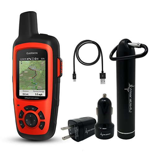
The Garmin InReach Explorer+ is a handheld satellite communicator with GPS navigation, maps, and offers an extra special feature for the ultimate adventurers who want to push their limits while also having the ability to call on help when they need it. Not just, WHENEVER they need it, but WHEREVER they need it.
The InReach Explorer+ is a satellite communicator and GPS navigator that uses 100% global Iridium coverage for 2-way messaging, tracking, and interactive SOS from anywhere in the world!
Going off-grid has never felt quite like this thanks to the Garmin InReach Explorer+. This machine is for the extreme among us who want to give the worriers in our lives peace of mind while simultaneously sailing off the edges of the Earth!
From the backcountry to far off foreign lands, whether on the water or in the air, the InReach Explorer+ keeps you connected! If you are always with InReach, then you are always within reach! Hey! I think we just coined that!
FEATURES:
EXPLORE ANYWHERE, GLOBAL COMMUNICATION
Using the worldwide coverage of the Iridium satellite network, these go-anywhere portable devices let you exchange text messages with any cell phone number or email address, all the while using GPS to track and share your journey’s progress. You can also post to social media or even communicate InReach-to-InReach in the field.
In case of an at-risk situation, you can also use InReach to trigger an SOS to the 24/7 monitoring center, text back and forth about the nature of your emergency, and receive confirmation when help is on the way!
NO CELL TOWER? NO PHONE SERVICE? NO PROBLEM
The InReach Explorer+ gives you all the tools to stay totally connected. You don’t have to worry about being within range of a cell tower or encountering spotty coverage in fringe zones or blackout areas. Your InReach communicator offers two-way messaging via the global Iridium satellite network.
TRACK AND SHARE YOUR WHEREABOUTS
Turn on the tracking function of your InReach Explorer+ communicator, and let family and friends follow your progress on their computers or mobile devices, using the web-based MapShare portal. The InReach device will send waypoints at preselected time intervals, so followers can track your whereabouts online.
You can also invite your crew back home to use MapShare to ping your InReach unit and see your GPS location, track your movements, and exchange messages during your trip. You can even embed your MapShare page on a blog, website or social media!
PAIR WITH YOUR MOBILE DEVICE
For even more capability and convenience, the free Earthmate app syncs your InReach handheld via Bluetooth with your compatible Apple or Android device so you can access unlimited maps, aerial imagery and U.S. NOAA charts.
Plus, Earthmate allows you to conveniently use all of the InReach features on your paired mobile device. For easier messaging, you can also access your phone’s contact list from the Earthmate app to connect with fewer keystrokes.
GET THE WEATHER WHEREVER & WHENEVER
The optional InReach weather forecast service provides detailed updates directly to your InReach device, compatible smartphone or tablet paired with the Earthmate app, so you’ll know what conditions to expect en route.
Basic and premium weather packages are offered. And you can request weather forecasts for your current location or any other waypoint or destination on your itinerary.
WHO WILL ANSWER YOUR SOS? GEOS WILL!
GEOS is the world leader in emergency response solutions and monitoring. They’ve supported rescues in more than 140 countries, saving many lives in the process. And they’re standing by 24/7/365 to respond to your SOS, track your device and notify the proper contacts and emergency responders in your area.
Then, while help is on the way, GEOS will continue to text back and forth with you, providing updates and critical information until your situation is resolved.
BUILT FOR THE RUGGED BACKCOUNTRY
Tough, durable, impact resistant, and water-rated to IPX7, the InReach Explorer+ handheld is built to keep you up and running, no matter what the elements throw at you. An internal, rechargeable lithium battery comes standard on this unit so you can count on long battery life in every mode of operation, and even up to 3 YEARS when powered off!!
ADDITIONAL AVIATION SERVICES
Your InReach Explorer+ is also a supported device for the Lockheed Martin Flight Services (LMFS) Adverse Condition Alerting Service (ACAS), Surveillance-Enhanced Search and Rescue (SE-SAR) and Enhanced Special Reporting Services (eSRS).
If you register for ACAS information, alerts provided via LMFS prompt you to call for an abbreviated briefing to address any specific adverse condition situation that might affect your flight-planned routing.
Likewise, automatic monitoring provided by the SE-SAR service enables the system to identify potential flight emergency situations and/or signals to promptly initiate search and rescue procedures for your aircraft.
SPECS:
PHYSICAL DIMENSIONS: 2.7" x 6.5" x 1.5" w/ keypad & SOS door bump
DISPLAY SIZE: 1.4"W x 1.9"H; 2.31" diagonal
DISPLAY RESOLUTION: 200 x 265 pixels
DISPLAY TYPE: transflective color TFT
WEIGHT: 7.5 oz
BATTERY: Rechargeable internal lithium-ion
BATTERY LIFE: Up to 100 hours at 10-minute tracking mode (default)
Up to 75 hours at 10-minute tracking with 1-second logging
Up to 30 days at the 30-minute interval power save mode
Up to 3 years when powered offWATER RATING: IPX7
RECEIVER INTERFACE: micro USB
MEMORY/HISTORY: 2 GB (user space varies based on included mapping)
“Not until we are lost do we begin to understand ourselves.”
—Henry David Thoreau
Despite all of the terrible things that go on in the world and how awful people and things can be, we must remember that even in darkness, there is light. It’s TRUE!
We must remember among all of this, that this ancient world is a magnificent, violent, heartbreakingly beautiful place. It is also indifferent. Nature is indifferent. It just keeps on. It keeps on providing us with the opportunity to get out and traverse it. To experience it in all of it’s gnarling and cunning, yet motherly form.
So use this technology if you choose. Go get lost. When you come back, things will still be here and probably much the same as you left them. Even during these times.
Get out and be in the natural world. It’s closer to what we’re meant to do and you may just begin to understand things a little better.

ABOUT